FAQ.ph

FAQ.ph is where you can read interesting facts, answers and frequently asked questions about the Philippines, its places, events and people.

  • Home
  • Travel
  • History
  • Society
  • Business
  • Politics
  • Technology
  • Lifestyle
  • Entertainment

How to Get to Sohoton Natural Bridge National Park

February 15, 2016 By Ge-Ann Balintec Leave a Comment

Enjoying at Sohoton River

Before Tacloban City was hit by Haiyan, it was just a small city slowly inching its way towards urbanization. However, when Haiyan hit, the landscape changed drastically. Yes, it seemed never to rise up from the rubbles again but two years after, it is a booming city with increasing traffic congestion.

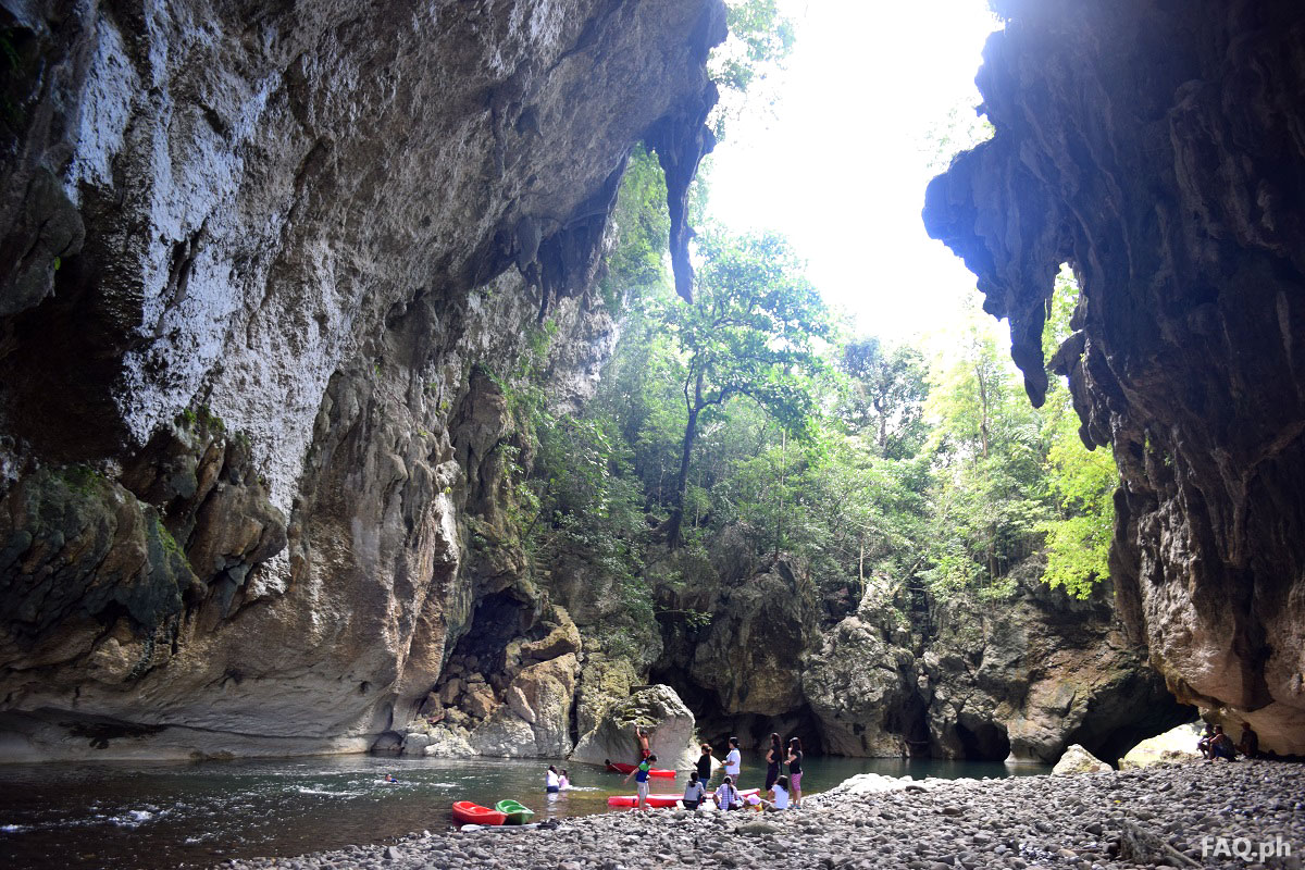
If you are the adventurous type, it might seem there is nothing to do in this nether region. I challenge you to drive even just 30 minutes away from the city’s traffic and you will be blown away by what this region has to offer. Largely undiscovered,rugged and off the beaten path, there is low tourist influx (except for the expat humanitarian aid workers) in the islands of Leyte, Samar and Biliran so you will rarely bump into a foreigner. This is why Elf Authentic Adventure chose the island of Samar in 1999 as a playground for hardcore outdoor adventure enthusiasts. [Read more…]

7 Yolanda Memorial Monuments in Leyte and Samar

November 10, 2015 By Lyza R. Sabornido Leave a Comment

The second year commemoration of the Super Typhoon Haiyan (Yolanda) went well. Even if it was raining, thousands of people in Eastern Visayas especially in Tacloban City took part of the various activities dedicated to the victims of the super typhoon which struck most part of the region during that frightful morning of November 8, 2013.

The highlights of the two-day commemoration was the candle lighting activity along the main streets of Tanauan, Tolosa, Palo and Tacloban City, unveiling of the memorial markers in Anibong, Sagkahan, and installation of the commemorative tablet at Daniel Z. Romualdez (DZR) Airport where Pope Francis celebrated a Holy Mass on January 7, 2015, a spot which was considered as ground zero during the said typhoon.

Speaking of memorials, there have been many memorials which have been built in honor of the victims and the people who helped the survivors to build back what was destroyed by Haiyan. Here are some pictures of the memorials made after super typhoon Yolanda:

1. M/V Eva Jocelyn Yolanda Memorial Marker, Anibong, Tacloban City

M/V Eva Jocelyn remnant, one of the cargo vessels washed ashore during the storm surge, made as a Yolanda Memorial Marker in Anibong, Tacloban City.

M/V Eva Jocelyn remnant, one of the cargo vessels washed ashore during the storm surge, made as a Yolanda Memorial Marker in Anibong, Tacloban City.

Unveiled on November 7, 2015. This is the actual bow of the M/V Eva Jocelyn made into a memorial marker. This memorial is in honor of the residents of Barangays; 67, 68, and 69 who died in that spot when this cargo vessel was swept ashore by a gigantic storm surge that was caused by the strong wind that reaches 375 miles per hour.

Read more about this here: The Unveiling of Anibong Memorial Marker

2. Yolanda Memorial Monument, Sagkahan, Tacloban City

The Astrodome Memorial Marker was unveiled on November 8, 2015 located in Sagkahan District, Tacloban City beside Tacloban Convention Center where more than 8 thousand people evacuated and survived the storm surge.

If you want to see more photos of Astrodome Memorial Marker more photos check out our facebook page here: FAQ.ph

3. Holy Cross Memorial Park, Brgy. Basper, Tacloban City

This mass grave is located in Brgy. Basper, Tacloban City is the final resting place of thousands of people who died during the Super Typhoon Yolanda. This was 3,000 white crosses were put on top of the mass grave as markers where families, relatives and friends could put a flower, light a candle and offer a prayer for their loved ones who lost their lives during the storm.

4. Araw Memorial Park, Government Center, Palo

Araw Memorial Park is located at Brgy Candahug, Palo, Leyte. This shows both the post Yolanda response and the sacrifices of Filipino soldiers during the Korean War in the 1950s.

This was unveiled on December 5, 2014 a few days before the South Korea Military Joint Support Group left. Since December 2013 the South Koreans were able to repair of 66 public buildings including; 37 schools and 25 government facilities. They also helped in the clearing operations, medical services and feeding programs.

To see more photos of Araw Memorial Park, check out our facebook page at FAQ.ph

5. Eternal Flame Memorial Garden Common Graves, Palo, Leyte

Eternal Flame Memorial Garden Common Graves located in Brgy. San Joaquin, Palo, Leyte is the final resting place of 378 residents of the said barangay who lost their lives to the Super Typhoon Yolanda.

The memorial is located right outside San Joaquin Parish. Names of the residents who were buried in the mass grave are written on granite. There is also a shade-like structure with names of the people who died including their birth date and death. There is also a sculpture of a candle at the center called “Eternal Flame”, instead of flame; a praying hand would be seen on top.

See more photos of this memorial here: FAQ.ph

6. Tanauan Yolanda Monument, Tanauan, Leyte

The place where Yolanda Monument stands now was once a mass grave located in Barangay Calogcog, Tanauan, Leyte. More than 200 people are buried in this memorial park which was blessed on March 31, 2015.

7. Yolanda Memorial Marker, Sta. Rita, Samar

The Yolanda Memorial Marker in Candaya Rotunda in Sta. Rita, Samar was put up and blessed last year during the commemoration of the Super Typhoon Yolanda.

These memorials will be there to remind us all and the next generation about the horrible devastation done by the strongest typhoon ever to hit the Philippines. They likewise represent the resilience of Filipinos that no matter how harsh the condition gets, no matter how much we lost, no matter how much pain we endure and how hopeless the situation gets, we will always get back on our feet and continue to fight back whatever challenges that may come our way.

Little by little we have recovered from the great loss. As we can see, most of the places which were greatly damaged two years ago are in a much better state than it was before. We can see new establishments opening which also opens an opportunity for a reliable income to the locals. As we move forward to a new and better life, may we never forget the people who helped us during the darkest days of Eastern Visayas. And may we also find it in our heart forgiveness for the people who did not despite their capacity to do so.

Samar Island: The Caving Capital of the Philippines and Home to the Biggest Cave in the Country

September 18, 2015 By Lyza R. Sabornido 2 Comments

Samar was put in the caving spotlight since the discovery of the biggest cave in the Philippines, the Langun Gobingob Caves in Brgy Panayuran, Calbiga, Samar. However, the island of Samar is not only home to the biggest cave in the country but it also hides the most amazing caves you will ever see in your life.

So if you’re a person who loves to explore and always ready for a great adventure, then set out on a journey to the third largest island of the Philippines, the island of Samar.

As of today, hundreds of caves has been discovered, mapped and catalogued by some Italian, French and Filipino speleologists in the island. And there might even be more than a thousand waiting to be discovered. No wonder why many adventure seekers from the Philippines and other countries have dared to visit and explored the caves of Samar.

The following caves are just some of the stunning caves that can be found in the island of Samar, which includes the provinces of Samar, Northern Samar and Eastern Samar. [Read more…]

20 Amazing Photos that Show why Samar is the Caving Capital of the Philippines

September 5, 2015 By Rig Man 8 Comments

The Philippine archipelago is home to beautiful islands, amazing diving spots, stunning waterfalls, and friendliest people in the world. That is why millions of tourists from around the globe are flocking to the country every year. However, the Philippines doesn’t only offer spectacular tourist destinations that can be reached on the ground, on top of the mountain or underwater. Our country also hides more incredible wonders of nature in the hollow places underground, the caves.

Caves are formed by nature over hundreds or even millions of years. Hidden in the darkness of caves are stunning rock formations called speleothems, which can also be classified into stalactites, helictites, stalagmites, flowstones, cave crystals and other types.

There are thousands of caves across the Philippines. Samar, alone, has already hundreds of caves that were indexed and there are even thousand more to be explored yet. The island of Samar is the third largest island in the Philippines, next to Luzon and Mindanao. It is where the current largest cave system in the Philippines (the Langun-Gobingob Caves in Calbiga) is located.

The island is not only hiding the largest cave in the country but also the most beautiful ones. Here are 20 amazing photos that will show you why Samar is the caving capital of the Philippines. [Read more…]

Top 12 Things to Do in Catbalogan City

August 24, 2015 By Rig Man 13 Comments

Catbalogan City is the capital of the province of Samar or Western Samar. It is a hundred kilometres away from Tacloban City, the regional center of Eastern Visayas. Catbalogan is known for its fishing industry that is why it is celebrating a month-long festivity called Manaragat Festival during the month of August. Manaragat means fishermen in English.

The 24th of August is the city’s Fiesta in honor of St. Bartholomew, the Patron Saint of Catbaloganons. I had the chance to explore this wonderful capital city of Samar and decided to write an article about it.

Whether you’re a Catbaloganon or a tourist who wants to explore this beautiful city, here are 12 things to do or places to visit within Catbalogan in no particular order.

[Read more…]

In Photos: Catbalogan City’s Manaragat Festival Parade 2015

August 23, 2015 By Rig Man Leave a Comment

Manaragat Festival Parade 2015

Manaragat is a Waray-Waray term that means fishermen. The Manaragat festival is an August month-long city festivity to honour St. Bartholomew, the miraculous Patron Saint of Catbalogan who maintains the richness of Magueda Bay as a fishing ground for Catbaloganons and all Samareños.

As one of the highlights in their month-long celebration, the people of Catbalogan hold a colourful parade every 23 of August, a day before the city’s fiesta (kaadlawan). The Manaragat Festival Parade is joined by various tribes or groups representing different barangays and schools from the City, as well as visitors from other parts of the Philippines.

During the parade, several festive dances characterized by colourful costumes and complex movements of different marine species inhabiting Maqueda Bay are presented by dancers. The dances are also executed in harmony with the sounds of drums and bugles that echo the culture of the long-lived fishing industry in Catbalogan.

In this year’s Manaragat Festival Parade, we had an opportunity to witness its grandeur. It’s our tradition to take photos of different festival parades from the different cities and towns of the Philippines, and we do it from an ordinary citizen’s point of view (no VIP or special media access) :).

Whether you missed the parade or you were there to watch it, here are some of the photos of Catbalogan City’s 2015 Manaragat Festival Parade. [Read more…]

10 Facts You Should Know about San Juanico Bridge in Samar and Leyte

September 17, 2014 By Lyza R. Sabornido 31 Comments

San Juanico Bridge in  Samar and Leyte

Tacloban City – The San Juanico Bridge connecting the provinces of Samar and Leyte is one of the monumental projects under Former President Ferdinand Marcos’ administration. It is known to be the longest bridge in the Philippines spanning a body of seawater with the length of 2.162 kilometers (1.34 mi) and width of 10.620 meters supported by 43 spans.

Since its completion in December 1972, the bridge has greatly helped the economy not only of both provinces connected but of the entire country.

It also attracted tourists because of the picturesque view it offers. I can still remember the feeling of my first visit there with my classmates in college. We went there to celebrate one of our classmates’ birthday. It was so exciting and scary at the same time. The view was so beautiful especially with the effects that the setting sun gave to the place but some of us can’t help but scream every time a bus or big trucks would pass because the bridge would shake a little. We also tried to count the whirlpools under the bridge but we gave up because height made us dizzy. [Read more…]

Advertisements

Join us on Facebook

FAQ.ph

Advertisements

About us

FAQ.ph stands for Facts, Answers and Questions about the Philippines. It is an online place where you can read interesting facts, useful answers and frequently asked questions about our country, its places, events and people. Our mission is to share stories that will help Filipinos and the world gain knowledge about everything in the Philippines, including its beautiful spots, rich history, unique society, and solutions towards the nation's progress.

More pages

  • About us
  • Privacy policy
  • Disclaimer
  • Advertise
  • Contact us

Latest comments

  • Anna May on How to Apply as a Voluntary Member with the Pag-IBIG Fund
  • John on Why So Many Filipinos Lack Discipline
  • Erlin on List of Postal Codes (ZIP codes) in the Philippines
  • Bo Tang on 14 Bad Habits that Filipinos should Break to Achieve Progress
  • Jay on 14 Good Filipino Habits that Make the Philippines a Great Country

© 2017 FAQ.PH All rights reserved.