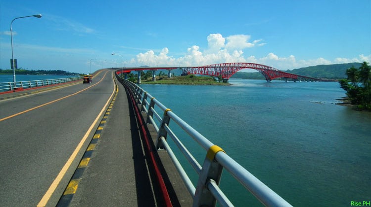
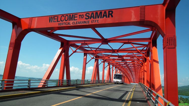
Tacloban City – The San Juanico Bridge connecting the provinces of Samar and Leyte is one of the monumental projects under Former President Ferdinand Marcos’ administration. It is known to be the longest bridge in the Philippines spanning a body of seawater with the length of 2.162 kilometers (1.34 mi) and width of 10.620 meters supported by 43 spans.
Since its completion in December 1972, the bridge has greatly helped the economy not only of both provinces connected but of the entire country.
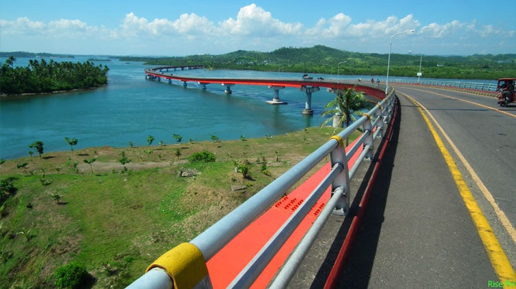
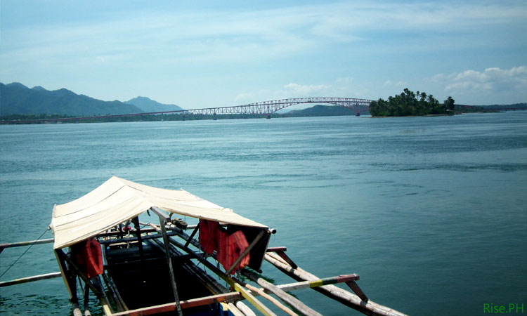
It also attracted tourists because of the picturesque view it offers. I can still remember the feeling of my first visit there with my classmates in college. We went there to celebrate one of our classmates’ birthday. It was so exciting and scary at the same time. The view was so beautiful especially with the effects that the setting sun gave to the place but some of us can’t help but scream every time a bus or big trucks would pass because the bridge would shake a little. We also tried to count the whirlpools under the bridge but we gave up because height made us dizzy.
A visit to Region VIII would truly never be complete if you won’t get to be on this bridge which looks like a dragon from afar. But even if people have been on it a few times, there are still so many things they don’t notice or know about it. Out of curiosity I did some research about San Juanico Bridge and here are some facts I think you would love to know about it:
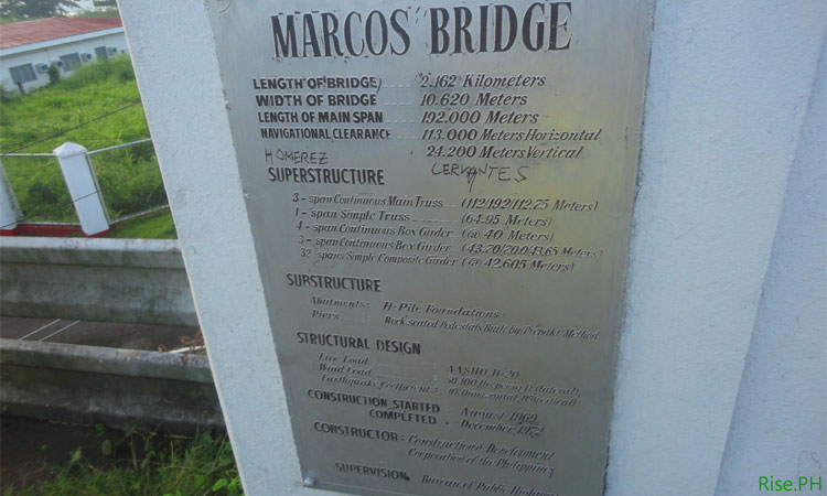
1. It was once called Marcos Bridge because it was built under his administration. During the mid 1960’s President Ferdinand Marcos made the decision to erect the San Juanico Bridge (aka “Marcos Bridge”) over San Juanico Strait from Brgy. Cabalawan, Tacloban City, Leyte, 10 KM away from the city proper (then Leyte Capital) to the Municipality of Sta. Rita, Western Samar, 96 KM from Catbalogan City (Samar Capital).
The said project was awarded to the Construction and Development Corporation of the Philippines in 1968. It was in that very year too that they started to conduct a detailed survey, study and analysis with the help of some Japanese engineers. In August 1969, the actual construction began and the Bridge was completed in December 1972.
2. It was also dubbed “The Bridge of Love”. As the late Philippine President, Ferdinand Marcos dedicated it to his wife, Imelda who was known as the “Rose of Tacloban“. It served as a birthday gift and testimonial of his love for her. The groundbreaking ceremony was done during the then first lady and now Ilocos Norte’s Representative Imelda Marcos’ birthday. Pres. Marcos even called it as his most important gift to his wife.
3. It’s part of the Maharlika Highway. San Juanico Bridge was constructed as part of the Pan-Philippine Highway (commonly known as the Maharlika Highway), a network of roads, bridges, and sea routes that connect the islands of Luzon, Samar, Leyte, and Mindanao in the country. The highway was proposed in 1965, and constructed under the administration of the late President Ferdinand Marcos to serve as the country’s backbone of transportation.
The Pan-Philippine Highway was also designated as Asian Highway (AH-26) under the Intergovernmental Agreement on the Asian Highway Network, a treaty took effect on July 4, 2005 to provide a framework for coordinated development of the international highways in Asia. Have you seen the sign AH-26 along our highway lately? Now you know what it means.
4. It shows my initials (L&S). If you look at the bridge from aerial or bird’s eye view, you can make out a shape of the letter “L” on the part near Leyte and “S” on the part going to Samar Province.
5. The $21.9 million worth of bridge was completed within four years of construction. This length of construction of this mega structure is way shorter compared to still unfinished roads in Samar.
6. It crosses the narrowest strait in the Philippines. San Juanico strait, which connects the islands of Samar and Leyte, is the narrowest strait in the Philippines with only two kilometers (2,000 meters) wide at its narrowest point. It is also said to be the narrowest in the world. However, Bosphorus strait, a strait that forms part of the boundary between Europe and Asia, is less than 800 meters wide at its narrowest point.
7. It is still considered the longest bridge in the Philippines. Although the Candaba Via duct in the province of Pampanga is longer, it’s not generally accepted because the latter is a land bridge crossing only a few streams and ponds.
8. A brave action star jumped off San Juanico Bridge in 1981. Directed by Carlo J. Caparas, Hari ng Stunt, shoot the most daring stunt done by Dante Varona to prove that he was the king of stunts in the Philippines.
9. The bridge remains strong and operational even after the rampage of Typhoon Haiyan in November 2013. Despite of the damages it incurred during the plight of super typhoon Yolanda, it still served as the primary means of the people from Samar who wanted to check on their relatives in Tacloban City.
10. P30, 000 to P35, 000 worth of bronze electrical wiring of the bridge were stolen from the bridge and reported missing in February 17, 2014. The bridge remained dark for a few nights after the incident, now the lights are back but the case remains unsolved (source: Manila Bulletin).
Up to this day, the bridge remains to be the main gateway of Eastern Visayas. It has attracted a lot of tourists from all over the world because of the magnificent view it offers. And it remains strong despite of its age and countless typhoons that have visited the country specially Region VIII. Some say that it was because of the rituals done during the construction of the bridge.
So have you been in Leyte and Samar? If not, make sure to put San Juanico Bridge at the top of your bucket list. Don’t miss the chance of setting foot on the historic and longest bridge in the Philippines. And I dare you to walk from end to end. Feel the sea breeze, experience the bridge shake, enjoy Samar and Leyte!
Editor’s Note: Previously, we have included as fact #3 the claim that San Juanico Bridge was designed by two Taclobanon architects, namely Juanito Isko Balunbalunan and Rodolfo Tokneneng, Jr. However, further research shows that there are no accurate and reliable sources proving this claim. We have updated the article to replace it with the fact that the bridge is part of the Maharlika Highway. We have also updated fact #6 to correct that San Juanico Strait is the narrowest strait in the Philippines, rather than in the world.
About Lyza R. Sabornido
Lyza writes to share the colorful and wonderful Filipino culture to the world. She's a seasoned writer, researcher and news reporter. She's the editor for lifestyle, culture and travel of FAQ.PH. Follow her on Twitter at @lyza_lyz.
YES Proud to be from Leyte….
proud to be leyteño
proud to be Waray!
SAME HERE I AM proud to be leyteño
matibay yan kasi hindi corrupt ang pagkakagawa….kung sa ngayong panahon yan ginawa ay ewan bumigay na yan for sure gagamitan yan ng mga sub standard na materials………..Proud Leyteno also
here……
Great facts
What a relief that it was built in the 70’s because if it was built now it’ll surely be substandard. Have to fill tons of pockets,
I remember the first time I walked from the highest point of the bridge up to the end. It was tiring and scary but all worth it though coz I did it. Haha!
Pres. Ferdinand E. Marcos is a True Hero, not by assasination but by his accomplishment and plans for the Filipino people.
I hope they have maintenance people assigned at this bridge to keep it in good shape physically.
tulay pala iton ha! Marisyu na! say paba kun adi na kamo ha amon ha region 8…. ano pang ina antay nyo, come! visit us and have fun….hehe
Glad to know facts about the San Juanico Bridge. I hate to hear people talk bad about Marcos especially WARAYS. He may have done some bad things …but the presidents after him …what have they done? STEAL!!! from the government and poor people. What would have happened without that bridge after Yolanda. I am proud to be a Taclobanon.
When Marcos was president he removed the 4billion USD loan ceiling of the country. Then he got a fresh loan of 23b USD. At that time the value of 1b USD is like building this longest bridge in the Philippines 45 times. Imagine what 23b USD can do at that time. Maybe we could catch up with Japan as the best in Asia.
To the author: correction on #2 – Imelda Marcos is NOT A NATIVE of Tacloban. She was in fact born in San Miguel, Manila. Her family moved to Tacloban by the time she was already 7 or 8 yrs old and then went back to Manila when she was 18 yrs old, where she met and married FM after 11 days of courtship. Thereafter, she lived in Manila na and goes back to Tacloban lang in times when it becomes stressful in Manila and she needs a vacation. So, practically she spent her whole life in Manila, except for the 10 yrs she lived in Tacloban during her younger years, so how can she be called a NATIVE of Tacloban?
Hi Michael. Thank you. We have already updated the article to reflect the correction.
Thank you for setting the facts straight. More power to you!
Imelda and Kokoy short lived in Guinarona, Dagami, Leyte where she almost drowned in Guinarona River and was saved by a farmer. Kokoy, her younger brother know almost everybody in Guinarona and he recalled all them if he drops by the place specially during campaign period.
Your info on Imelda’s age when she moved back to Manila is incorrect. She couldn’t be 18 because: (1) She had finished college at St. Paul’s College Tacloban when she left Leyte, (2) She was 18 when she was crowned Rose of Tacloban, and (3) Various online sources say that she moved to Manila in 1950 and at the time she was already 21 years old. By the way, what authoritative definition of “native” are you basing your conclusion from?
18 or 21 does not matter…the fact is, she was not born here and then left Tacloban and practically spent all of her adult life in manila except for some vacay back here in Leyte…and just look up in the dictionary the meaning of native.
You were the one who started this thing about “setting the facts straight”. Be responsible.
bbm
You are the BS..the issue here is : Imelda is NOT a native and it was just corrected. A native, for your info, is someone BORN in that place. The author is not a dumbass to accept the info i provided and may have researched into that info that is why a correction was made. I bet you are an Imelda fanatic that is why you are reacting adversely to this. I have no other intention except to set the fact straight that she is NOT a native Taclobanon.
Thanks for the info
Thanks for this write up specially the newest and clear photos. I have many shots of San Juanico Bridge but they are not as clear as these. It needs a very good weather to capture and at the right angle.
Here are some additional info. 1. The Bridge is the NARROWEST NAVIGABLE Bridge in the World
2. The L & S or whatever shape you call turned how it is because the ENGINEERS followed the water Current or directions of the flow of water (which are many circular) in order to make the bridge durable or lasting and withstand the strong Winds. This, I think only few knows. I was in Tacloban when the construction started until it was almost finished . I visited often the construction site and asked later why the form is different. The Filipino Engineer answered. This is a proof of the efficiency of the Filipinos working with the Japanese Engineers. This is one of my highlights in my prepared Eco & Aqua tour packages of Eastern Samar. Pls. Google: Mangroves of Cagaut River, Salcedo, Eastern Samar
This only shows that you are a fool, that your observation is in the context of foolishness, baseless, and merely an independent observation as your name suggest because it did not depend on the facts. Try to visit the place yourself, research and study on how it will contribute to the economy, how it will save the amount of time and money out of building it rather than, having a RORO that would connect the 2 provinces from the time it was built until now. You’re not even reading the article comprehensively the fact that the bridge connects not only Leyte and Samar but Mindanao and Luzon…
Breathtaking as it was solidly-built! Now i wonder how many more were built that would equal this little engineering marvel and dandy landmark? NONE! Because only a Marcos has the political will and vision to do great things that last.
Mga pilipino, mas maganda na wag na tayo lagi magreklamo sa ating gobnyerno dahil ang pagiging presidente ay isang mahirap na layunin sa buhay. Dapat na lang natin tulungan ang gobnyerno sa kanilang gustong gawin sa pilipinas kay sa magreklamo na lang lagi. Tingnan niyo ang mga sarili ipinagbaba ang sariling bansa, ang iba ay nagiging OFW dahil sa walang trabaho dito at mas malaking kita doon. Naiwanan na ang pilipinas , Unti unti nawawala ang identibidad ng mga bagong pilipino alam ko na ayaw niyo tuloy mawala and ating mga identibidad kaya wag niyo ipagpataas ang ibang bansa halimbawa ang America. Colonial na pagiisip ito .. Ang ipinagtataas ang ibang bansa kay sa sarili natin. Tingnan niyo and mga tsino hindi nila inuuna ang pagkaka English kundi inuuna nila ang sarili nilang linguahe at wika. Pag tinanong niyo ngayon ang mga pilipino ngayon kung anong linguahe ang maganda para sa kanila … Ang kanilang mga sagot ay ibat iba … May mga Pilipino, May mga English … Ang sinasabi ko lang na kay sa gumaya sa lipunan ng pilipino ngayon, dapat tayo ang magiba ng kultura natin kay sa makisabay na lang dun sa mga Panget na Ugali ng mga pilipino .
yeah…i was disappointed when i saw the red color and contraption above it…
i am filipino puwde na hahahahahah
Hello, nice article about SJ Bridge… wanna know more???? the year this was proposed was preMartial Law days. It was originally under the administration of Macapagal days, Diosdado. The real builders can be found and those who conceptualized this bridge so as the PAN PHIL HWY… then 1972 came… everything disappeared esp… the real people behind the SJ bridge….
We were there last week… The view was amazing! Proud to have gone there!